Does Sector Mapping Really Matter in the Farm
Farm and Sector Mapping at Jessie’s Sunshine Farm
At Jessie’s Sunshine Farm, mapping is more than a documentation — it’s the backbone of our agroforestry system and the key to long-term sustainability. Every section, tree row, and access road is strategically planned to balance productivity, ecology, and maintenance. Here we document the intercropping maps of our sectors.
Workers can efficiently track weeding, pruning, pest treatment, curing of diseases, and harvest schedules. Each tree is mapped for easy monitoring, allowing data-driven management that saves time and reduces inputs. This structure transforms daily farm operations into a coordinated, traceable system.
Sectoring the farm
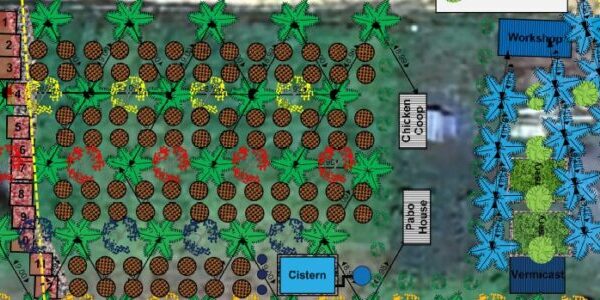
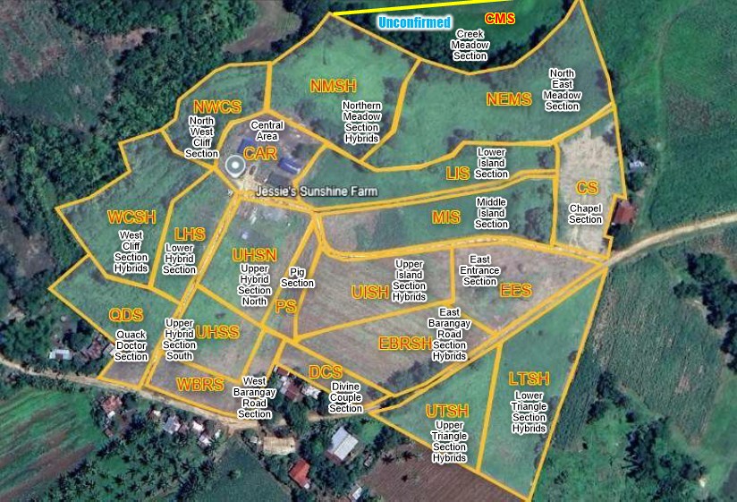
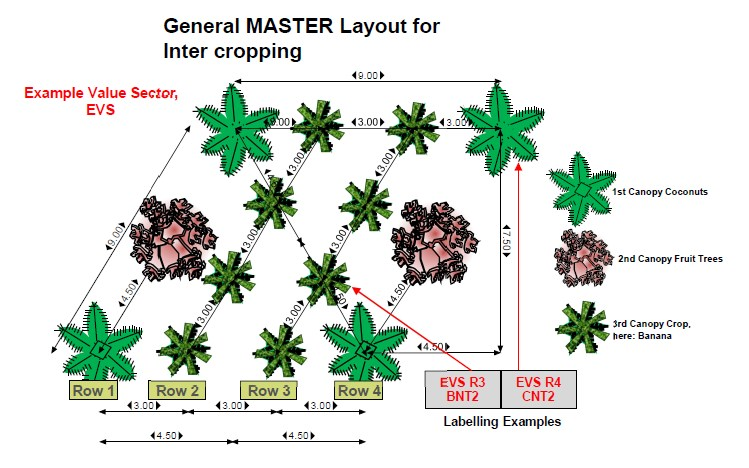
Our farm divides into 20 labeled and defined sectors. Each sector has its unique crops. Basically, all of them have coconuts as their first canopy, planted mostly in triangular and two sectors also planted in square pattern. As the second canopy, we have been planting fruit trees during Phase 3. These fruit trees are value fruit trees. Hybrids or grafted ones. They have been planted in the mid point between two coconut trees. Correct pruning will be important here. The third canopy is defined as two interlining rows between the coconuts trees. These two extra rows are spaced at an 3 meter distance. Within these interlines we space crops at 3 meters distance from each other. In this setup we have a 3 meter access in between two line. Great for small farm vehicles.
All Sectors of the Farm
- Triangle
- Upper Farm
- Lower Farm
Labelling the Rows
Each row has a label for identification containing a sector name and a row number. All trees are counted from the label as the first count. Hence LHS Row 4 CNT 2, translates into Lower Hybrid Section, row 4, Coconut tree #2. In this way trees that need treatment can be identified easily.
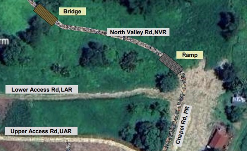
Naming Our Roads
Naming our access roads — such as West Barangay Road, WAR, Hybrid Road, HBR, Pig Road, PR, and Divine Couple Road, DCR — brings logistical clarity. Deliveries, harvesting teams, and emergency responses are guided safely and efficiently through clearly identified routes.
Therefore, all access road, some main roads and some just for maintenance access, will have signages. You can find the street maps here too.
All Roads on the Farm
- Triangle
- Upper Farm
- Lower Farm
Maps of Crops in Jessie’s Sunshine Farm
Upper Triangle Section, UTSH
- Canopy, Hybrid Coconuts
- Canopy, Pomelo Fruit Trees
- Canopy, calamansi
- Oil Palms
Lower Triangle Section, LTSH
- Canopy, Hybrid Coconuts
- Canopy, American Lemon
- Canopy, Calamansi
- Oil Palms
Chapel Section, CS
- Canopy, Catigan Dwarf Coconuts
- Canopy, Lanzones Trees
- Canopy, Saba Bananas
- Oil Palms
Lower Island Section, LIS
- Canopy, Catigan Dwarf Coconuts
- Canopy, Pomelo
- Canopy,
Latundan Bananas
Guavapple
Middle Island Section, MIS
- Canopy, Catigan Dwarf Coconuts
- Canopy,
Jackfruit
Sweet Guyabano - Canopy, Morado and Tinduk Bananas
- Oil Palms
Upper Island Section, UISH
- Canopy, Hybrid Catigan Coconuts
- Canopy, Mangga Cebu Fruit Trees
- Canopy, Lakatan Bananas
East Entrance Section, EES
- Canopy, Catigan Dwarf Coconuts
- Canopy, Mangga Cebu Fruit Trees
- Canopy, Saba Banana
- Oil Palms
East Baragagay Rd Section Hybrid, EBRSH
- Canopy, Hybrid Catigan Coconuts
- Canopy, Mangga Cebu Fruit Trees
- Canopy, Atis Fruit
- Oil Palms
Divine Couple Section, DCS
- Canopy, Hybrid Catigan Coconuts
- Canopy, Indian Mango Fruit Trees
- Canopy, Lakatan Bananas
- Oil Palms
Pig Section, PS
- Canopy, Catigan Dwarf Coconuts
- Canopy,
Tabon Tabon
Purple Mango - Canopy, Latundan Bananas
West Barangay Rd Section, WBRS
- Canopy, Catigan Dwarf Coconuts
- Canopy,
American Lemon
Pomelo
Sweet Guyabano
Bangkok Santol - Canopy, Saba Banana
- Oil Palms
Upper Hybrid Section South, UHSS
- Canopy, Hybrid Catigan Coconuts
- Canopy,
American Lemon
Pomelo
Sweet Guyabano
Bangkok Santol - Canopy, Oranges
Upper Hybrid Section North, UHSN
- Canopy, Hybrid Catigan Coconuts
- Canopy,
American Lemon
Pomelo
Sweet Guyabano
Bangkok Santol - Canopy, Oranges
- Oil Palms
Quack Doctor Section, QDS
- Canopy, Catigan Dwarf Coconuts
- Canopy,
American Lime
Guavapple - Canopy, Saba Bananas
- Oil Palms
Lower Hybrid Section, LHS
- Canopy, Hybrid Catigan Coconuts
- Canopy,
American Lime
Guavapple - Canopy,
Madre de Aqua
Papayas
Central Area, CAR
- Canopy,
Oil Palms
Rambutan
Avocado
West Cliff Sections, WCS
- Canopy, Hybrid Catigan Coconuts
- Canopy, Lanzones
- Canopy, Robusta Coffee
North West Cliff Sections, NWCS
North Meadow Sections, NMS
- Canopy, Hybrid Catigan Coconuts
- Canopy, Lanzones
- Canopy, Coffee
North-East Meadow Sections, NEMS
Visit our Fruit Trees
At Jessie’s Sunshine Farm, our diverse collection of fruit trees forms the foundation of a thriving agro-ecological system designed for productivity, balance, and sustainability. Each tree species was carefully chosen to complement the tropical environment of Mindanao, ensuring year-round harvests and ecological harmony under the protective canopy of our coconuts.
Coconut our Main Crop
The coconut serves as the backbone of Jessie’s Sunshine Farm, forming the primary canopy that shapes the farm’s structure and microclimate. Its towering palms provide shade, wind protection, and organic mulch from fallen fronds.
🗺️Summary – Why Mapping Matters
1️⃣ Organized Agroforestry Design
- 20 clearly defined sectors for coconuts, fruit trees, and livestock.
- Promotes efficient use of sunlight, soil, and water.
2️⃣ Precision in Maintenance
- Labeled rows, like UHSN 4-7 or LHS 7-2, streamline weeding, pruning, pest treatment, curing diseases, and harvesting.
- Enables accurate recordkeeping and input tracking.
3️⃣ Sustainable Resource Management
- Mapping guides irrigation, compost application, and nutrient cycles.
- Reduces chemical waste and prevents erosion.
4️⃣ Road and Access Coordination
- Named routes (West Access Road, Northern Valley Road, , Divine Couple Road, Pig Road, etc) ensure safe and efficient transport.
- Critical for logistics and emergency response.
5️⃣ Climate Resilience and Research
- Supports contour farming, biodiversity monitoring, and soil health analysis.
- Forms are a living record for future planning and adaptation.
6️⃣ Faith-Based Stewardship
- Mapping expresses responsible dominion — caring wisely for God’s creation.
- Every labeled sector and path reflects gratitude and purpose in farming.